Orogenic Exploration Pty Ltd
Welcome
Consulting
• Australian Potash Brine
• Capturing Data
• Ellendale Lamproite
• Parnaroo Loam Grid
• World Map Index
Projects ↴
• Flinders Island
Previous Projects ↴
• Eyre Peninsula
• Shell Lagoon
• Terowie South
Project Generation
Image Galleries ↴
• Diamond Exploration
• Metal Exploration
Contact
Ellendale Lamproite Field
The attached maps cover an area of about 2500 square kilometres over the Ellendale Lamproite Field, in the far northern part of Western Australia. The field contains many diamond bearing lamproite intrusions, including two, Ellendale 04 (E04) and Ellendale 09 (E09) that until recently were commercially mined for diamonds.
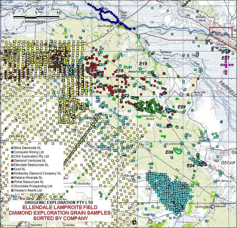
The first map shows over 5000 samples collected from the surface and below (by drillhole or trench) and examined for diamonds and indicator minerals (rare specific mineral grains associated with lamproites and kimberlites) since 1969 by various companies. Most samples are normal heavy mineral samples examined for grains above around 0.3 or 0.4mm in size, but CRA Exploration Pty Ltd and some later smaller companies routinely also examined the fine fraction using acid/caustic digest to recover microdiamonds (generally in size range 0.1-0.4mm).

Surface Diamonds
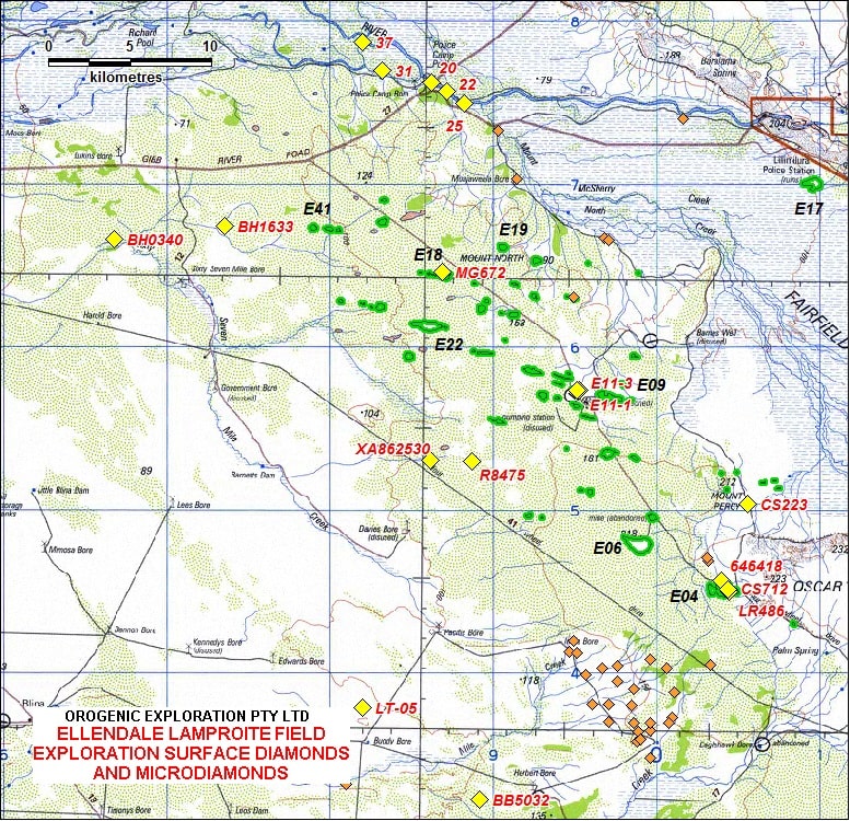
The second maps shows that despite over 3300 samples collected from the surface and grains examined, only 18 separate samples recovered diamonds by standard heavy mineral processing and observation. The lower screen size and thus the smallest diamond that can be recovered can range from 0.25 to 0.4mm but can be as large as 1.0mm depending on company and the program.

The first diamonds recovered in the region were by Exoil NL from gravels along the Lennard River in 1969 (north side of map). The AMDEL laboratory (Adelaide) recovered six stones and three cleaved fragments from five samples (20, 22, 25, 31, 37) out of a total of 37 sample. A follow-up program of 16 samples, each one tonne of excavated gravel along the river, failed to recover any further diamonds. The later larger samples were mostly only examined down to 0.85mm by hand sorting jig concentrates in the field (Haynes, 1971), while the laboratory samples were all examined down to 0.35mm, and some even finer (AMDEL, 1970). This highlights the need to always specify the size range observed when comparing sample results due to the particulate nature of sampling for mineral grains.
Most of the samples on the western side of the map were collected by Stockdale Prospecting (De Beers subsidiary) during the period of 1986 to 1991 utilising their practice of taking systematic surface loam samples, with observation down to 0.4 or 0.3mm to locate indicator mineral anomalies. They recovered only four diamonds (samples BB5032, BH0340, BH1633 & R8475) from surface but did outline a large indicator anomaly and discovered five new lamproites (but these were barren for diamonds in fractions observed). No microdiamond analyses was routinely completed by Stockdale, or most of the other companies on surface samples.
The eastern side has mainly been held by CRA Exploration Pty Ltd (under the Ashton JV) starting from 1976 and their exploration methodology was more based on checking aerial magnetic targets by using shallow auger holes and geochemical analyses of the bottom sample to confirm the rock type that was below the sandy soil cover. Their aim was to quickly locate every large lamproite using this method, then rely on indicator sampling of trench and drill samples to determine the diamond content of each discovered intrusion. Only selected surface samples were collected for indicator examination and this included examination for microdiamonds in the ultra fine fraction (generally 0.1-0.3mm) using acids to digest the samples.
In the mid 1980's CRA Exploration completed a surface loam grid sampling program over the area southwest of Ellendale 04 which included routine digests for recovery of microdiamonds. This sampling shows a spread of microdiamods (smaller brown diamond symbol on map) over the area sampled but CRAE did not regard them as significant for the general area (Haebig, 1987). Remaining surface microdiamonds on the second map were also recovered after digestion by Blina Diamonds NL during more recent exploration.
Sub-surface Diamonds
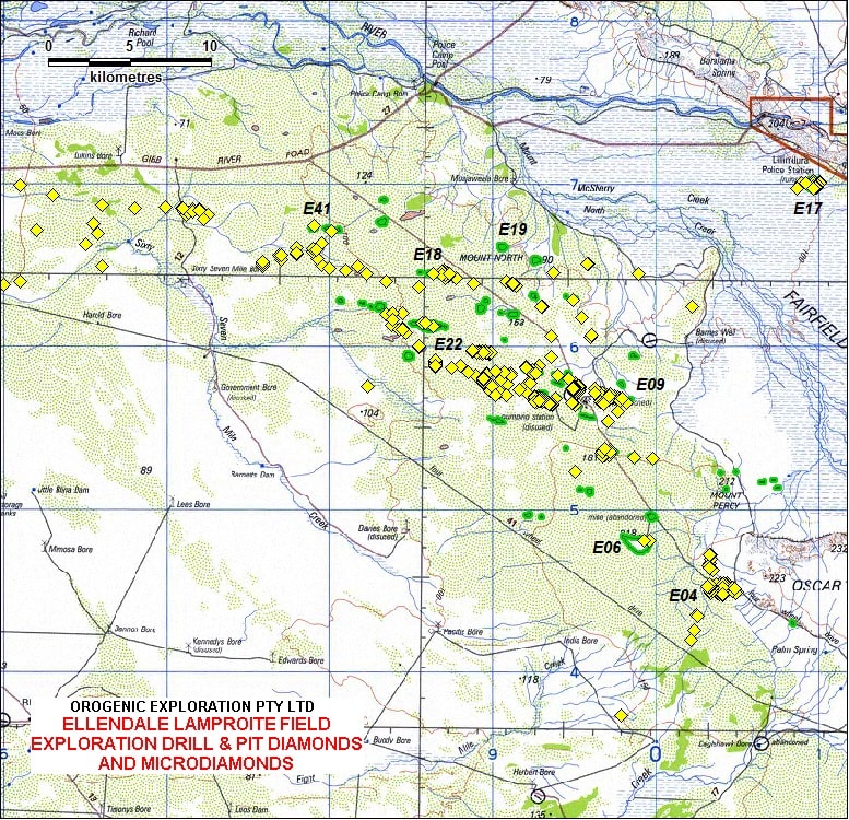
The full diamondiferous nature of the Ellendale Lamproite Field is highlighted in the third map which shows samples recovered below the surface by drilling or trenching that contain diamonds (the location of over 10,000 diamonds recovered is shown). As most of the olivine lamproites are beneath a cover of recent sands only sub-surface diamond sampling reliably highlights which ones are diamondiferous. Many early drillholes and pit were not sampled for diamonds or indicator minerals as their sole purpose to discover lamproite using visual examination and whole rock geochemical analyses of the drill or excavation spoil.
The buried diamonds not recovered from within lamproite intrusions occur in gravels from previous ancient rivers and are also mostly hidden below sands. The elongated pattern of the buried gravel drainage containing diamonds can be clearly seen and these gravel diamonds are the exploration target of the current Blina Diamond Project of Phosphate Australia Ltd.

These maps show that even in an area with minable diamond bearing intrusions, if the diamond prospectivity of an area is based solely on the number of diamonds recovered from surface sampling then opportunities could be missed. Attention to detail including what was the material sampled and which size fractions are examined are important in comparing diamond exploration results. To say some rock or area is barren for diamonds should specify what size range was tested.
Extensive conventional heavy mineral indicator sampling shows only limited amounts surface diamonds In this area of concealed diamondiferous lamproite. But the systematic microdiamond digest sampling over the limited small area available would indicate that microdiamonds (<0.4mm) are more widely distributed on the surface than diamonds above 0.4mm in size.
Authorised by Steven Cooper
Maintained by Ian Savicky
Copyright Notice and Disclaimer